Share Lambeth Neighbourhood Connectivity Plan on FacebookShare Lambeth Neighbourhood Connectivity Plan on TwitterShare Lambeth Neighbourhood Connectivity Plan on LinkedinEmail Lambeth Neighbourhood Connectivity Plan link
About this project
As part of its commitment to providing safe, convenient and accessible mobility choices for all residents, City Council has directed staff to develop a “Neighbourhood Connectivity Plan” for the Lambeth area. The plan will identify where new sidewalks can provide the most value.
Thank you to everyone who took the time to submit feedback at the in-person event on June 10, as well as by phone, email, and online over the summer. The City hosted an online webinar on June 12 at 12noon. A recording can be viewed online here.
City staff will be bringing a report to City Council’s Community and Protective Services Committee on November 10, 2025, with recommendations on where new sidewalks should be implemented in your neighbourhood.
The recommendations are now posted below to provide time for residents to review and decide whether they wish to provide further comment through the public participation meeting (PPM) process at the November 10 meeting.
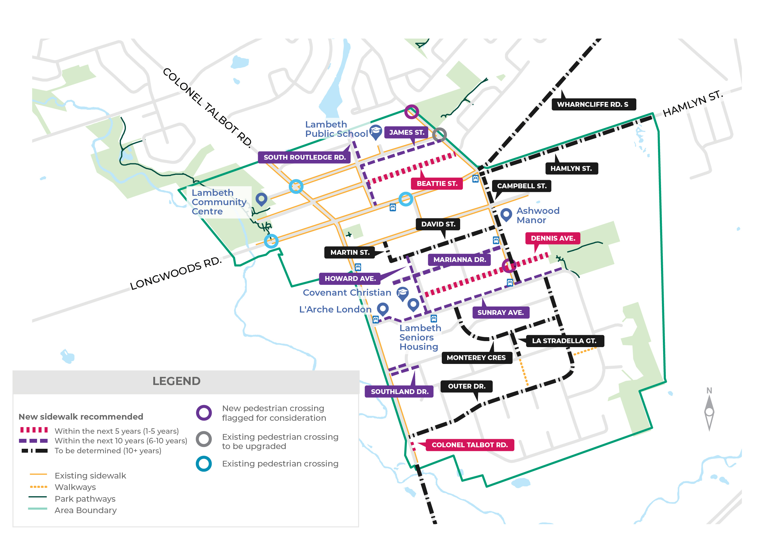
Above: a map of the Lambeth Neighbourhood Connectivity Plan recommendations
Lambeth Neighbourhood Connectivity Plan Recommendations The following streets currently have no sidewalk. A sidewalk is recommended on one side of the following streets:
Street
Timing (years)
Location
Program*
Hamlyn Street
10+
Wharncliffe Road to Wonderland Road
NSP
Martin Street
10+
Broadway Avenue to David Street
NSP
David Street
10+
Martin Street to Campbell Street
NSP
Marianna Drive
6-10
West limit to Campbell Street
NSP
Dennis Avenue
1-5
Howard Avenue to Ralph Hamlyn Park
LRRP
Sunray Avenue
6-10
Colonel Talbot Road to Ralph Hamlyn Park
NSP
Howard Avenue
6-10
David Street to Sunray Avenue
NSP
Monterey Cres
10+
Sunray Avenue to Outer Drive
NSP
La Stradella Gate
10+
Monterey Cres to Scottsdale Street
NSP
Outer Drive
10+
Colonel Talbot Road to Sunray Avenue
NSP
Colonel Talbot Road
1-5
Outer Drive to MN 4690
NSP
Colonel Talbot Road
10+
MN 4690 to Greenhills Country Club
ARRP
The following streets currently have sidewalk on one side. A sidewalk is recommended on both sides of the following streets:
Street
Timing (years)
Location
Program*
Colonel Talbot Road
10+
Sunray Avenue to Outer Drive
-
James Street
6-10
Campbell Street to South Routledge Road
NSP
South Routledge Road
6-10
Main Street to north limit
NSP
Campbell Street
10+
Wharncliffe Road to Sunray Avenue
NSP
The following streets currently have no sidewalks. Sidewalks are recommended on both sides of the following streets:
Street
Timing (years)
Location
Program*
Beattie Street
1-5
South Routledge Road to Campbell Street
NSP
Southland Drive
6-10
Colonel Talbot Road to Gustin Avenue on North Side and Scottsdale Street on South Side
NSP
The following park pathway is recommended for extension:
Street
Timing (years)
Location
Program*
Ralph Hamlyn Park
10+
From Ralph Hamlyn to Sandra McInnis Woods through Hydro One Corridor
NOS
The following major road improvement will include sidewalks:
Street
Timing (years)
Location
Program*
Wharncliffe Road
10+
Campbell Street to Wonderland Road
GP
The following pedestrian crossing locations will be reviewed further:
Street
Timing (years)
Location
Program*
Campbell Street
1-5
Intersection of James Street (upgrade to existing PXO-D)
RSS
Campbell Street
6-10
Crossing at new walkway connection to Lambeth Public School
RSS
Dennis Avenue
1-5
Intersection of Campbell Street and Dennis Avenue
RSS
Table Legend: *Programs: Sidewalks and pedestrian supportive infrastructure are constructed under various infrastructure programs:
LRRP – Local Road Reconstruction Program
NSP – New Sidewalk Program
IRP – Infrastructure Renewal Program
NOS – New Open Space Program (Park Pathways)
GP – Growth Projects
ARRP – Arterial Road Rehabilitation Program
RSS – Road Safety Strategy
A total of 11 streets and 7 courts/places, listed below, have been recommended for exemption from the requirements of Mobility Policy 349 of The London Plan. These streets carry low traffic volumes and have no pedestrian connections. In recognition of resident feedback and in consideration of impacts to trees and driveways it is recommended that no new sidewalks be installed at these locations. Under this exemption, no new or additional sidewalks will be constructed at the following locations:
Lambeth Walk
Bainard Street
Lynne Avenue
Gustin Avenue
Field Road
Scottsdale Street
Patrick Street
Kirk Drive
Beech Drive
Sunray Avenue (south of Ralph Hamlyn Park)
Southland Drive (east of Scottsdale Street)
Scottsbury Place
Suffield Court
Stanton Place
Caldwell Place
Greenhills Place
Selden Court
Aspen Place
How to join the public participation meeting (PPM) The November 10 meeting includes a public participation meeting (PPM) component, meaning you can speak directly to the Community and Protective Services Committee at this meeting, or email comments to the City Clerk’s Office in advance to have them included in the Community and Protective Services Committee agenda.
What happens after City Council’s decision? Following Community and Protective Services Committee, Council will meet on November 25 to give final direction on the staff recommendations. When it’s time to construct sidewalks where they have been approved, staff would then return to consult with those residents, with a focus on finding the best fit for the street and helping residents understand the design considerations available to maximize the benefits and mitigate impacts of adding a new sidewalk.
Please contact us at ncp@london.ca if you have any questions about next steps.
About this project
As part of its commitment to providing safe, convenient and accessible mobility choices for all residents, City Council has directed staff to develop a “Neighbourhood Connectivity Plan” for the Lambeth area. The plan will identify where new sidewalks can provide the most value.
Thank you to everyone who took the time to submit feedback at the in-person event on June 10, as well as by phone, email, and online over the summer. The City hosted an online webinar on June 12 at 12noon. A recording can be viewed online here.
City staff will be bringing a report to City Council’s Community and Protective Services Committee on November 10, 2025, with recommendations on where new sidewalks should be implemented in your neighbourhood.
The recommendations are now posted below to provide time for residents to review and decide whether they wish to provide further comment through the public participation meeting (PPM) process at the November 10 meeting.
Above: a map of the Lambeth Neighbourhood Connectivity Plan recommendations
Lambeth Neighbourhood Connectivity Plan Recommendations The following streets currently have no sidewalk. A sidewalk is recommended on one side of the following streets:
Street
Timing (years)
Location
Program*
Hamlyn Street
10+
Wharncliffe Road to Wonderland Road
NSP
Martin Street
10+
Broadway Avenue to David Street
NSP
David Street
10+
Martin Street to Campbell Street
NSP
Marianna Drive
6-10
West limit to Campbell Street
NSP
Dennis Avenue
1-5
Howard Avenue to Ralph Hamlyn Park
LRRP
Sunray Avenue
6-10
Colonel Talbot Road to Ralph Hamlyn Park
NSP
Howard Avenue
6-10
David Street to Sunray Avenue
NSP
Monterey Cres
10+
Sunray Avenue to Outer Drive
NSP
La Stradella Gate
10+
Monterey Cres to Scottsdale Street
NSP
Outer Drive
10+
Colonel Talbot Road to Sunray Avenue
NSP
Colonel Talbot Road
1-5
Outer Drive to MN 4690
NSP
Colonel Talbot Road
10+
MN 4690 to Greenhills Country Club
ARRP
The following streets currently have sidewalk on one side. A sidewalk is recommended on both sides of the following streets:
Street
Timing (years)
Location
Program*
Colonel Talbot Road
10+
Sunray Avenue to Outer Drive
-
James Street
6-10
Campbell Street to South Routledge Road
NSP
South Routledge Road
6-10
Main Street to north limit
NSP
Campbell Street
10+
Wharncliffe Road to Sunray Avenue
NSP
The following streets currently have no sidewalks. Sidewalks are recommended on both sides of the following streets:
Street
Timing (years)
Location
Program*
Beattie Street
1-5
South Routledge Road to Campbell Street
NSP
Southland Drive
6-10
Colonel Talbot Road to Gustin Avenue on North Side and Scottsdale Street on South Side
NSP
The following park pathway is recommended for extension:
Street
Timing (years)
Location
Program*
Ralph Hamlyn Park
10+
From Ralph Hamlyn to Sandra McInnis Woods through Hydro One Corridor
NOS
The following major road improvement will include sidewalks:
Street
Timing (years)
Location
Program*
Wharncliffe Road
10+
Campbell Street to Wonderland Road
GP
The following pedestrian crossing locations will be reviewed further:
Street
Timing (years)
Location
Program*
Campbell Street
1-5
Intersection of James Street (upgrade to existing PXO-D)
RSS
Campbell Street
6-10
Crossing at new walkway connection to Lambeth Public School
RSS
Dennis Avenue
1-5
Intersection of Campbell Street and Dennis Avenue
RSS
Table Legend: *Programs: Sidewalks and pedestrian supportive infrastructure are constructed under various infrastructure programs:
LRRP – Local Road Reconstruction Program
NSP – New Sidewalk Program
IRP – Infrastructure Renewal Program
NOS – New Open Space Program (Park Pathways)
GP – Growth Projects
ARRP – Arterial Road Rehabilitation Program
RSS – Road Safety Strategy
A total of 11 streets and 7 courts/places, listed below, have been recommended for exemption from the requirements of Mobility Policy 349 of The London Plan. These streets carry low traffic volumes and have no pedestrian connections. In recognition of resident feedback and in consideration of impacts to trees and driveways it is recommended that no new sidewalks be installed at these locations. Under this exemption, no new or additional sidewalks will be constructed at the following locations:
Lambeth Walk
Bainard Street
Lynne Avenue
Gustin Avenue
Field Road
Scottsdale Street
Patrick Street
Kirk Drive
Beech Drive
Sunray Avenue (south of Ralph Hamlyn Park)
Southland Drive (east of Scottsdale Street)
Scottsbury Place
Suffield Court
Stanton Place
Caldwell Place
Greenhills Place
Selden Court
Aspen Place
How to join the public participation meeting (PPM) The November 10 meeting includes a public participation meeting (PPM) component, meaning you can speak directly to the Community and Protective Services Committee at this meeting, or email comments to the City Clerk’s Office in advance to have them included in the Community and Protective Services Committee agenda.
What happens after City Council’s decision? Following Community and Protective Services Committee, Council will meet on November 25 to give final direction on the staff recommendations. When it’s time to construct sidewalks where they have been approved, staff would then return to consult with those residents, with a focus on finding the best fit for the street and helping residents understand the design considerations available to maximize the benefits and mitigate impacts of adding a new sidewalk.
Please contact us at ncp@london.ca if you have any questions about next steps.
Lambeth Neighbourhood Connectivity Plan is currently at this stage
City staff will be bringing a report to City Council’s Community and Protective Services Committee on November 10, with recommendations on where new sidewalks should be implemented in your neighbourhood.
Street-level consultation
this is an upcoming stage for Lambeth Neighbourhood Connectivity Plan
After Council approval of your Neighbourhood Connectivity Plan, staff will come back to the streets where sidewalks have been recommended to consult with those residents to determine the best sidewalk design for the street.
The personal information submitted on this page is collected under the authority of the Municipal Act, 2001, S.O. 2001, c. 25 and will be used to provide details regarding the Hamilton Road Neighbourhood Connectivity Plan.
Questions about this collection of personal information should be addressed to Daniel Hall at 300 Dufferin Ave., London, ON N6A 4L9, or by telephone at 519-661-2489 ext. 4255, or email to dhall@london.ca