Hamilton Road Neighbourhood Connectivity Plan

Share Hamilton Road Neighbourhood Connectivity Plan on Facebook Share Hamilton Road Neighbourhood Connectivity Plan on Twitter Share Hamilton Road Neighbourhood Connectivity Plan on Linkedin Email Hamilton Road Neighbourhood Connectivity Plan link

About this project

As part of its commitment to providing safe, convenient and accessible mobility choices for all residents, City Council has directed staff to develop a “Neighbourhood Connectivity Plan” for the Hamilton Road and Fairmont area east of Highbury Avenue. The plan will identify where new sidewalks can provide the most value.

The current phase of consultation ended on July 8, 2024. Thank you to everyone who joined us at our meeting at St. Bernadette Catholic School on June 3, and who attended our online webinar on June 5. A recording of the webinar is included below on this webpage.

City staff will be bringing a report to City Council’s Community and Protective Services Committee on December 2, 2024, with recommendations on where new sidewalks should be implemented in your neighbourhood.
A button that says "Subscribe for updates"


Hamilton Road Neighbourhood Connectivity Plan Recommendations
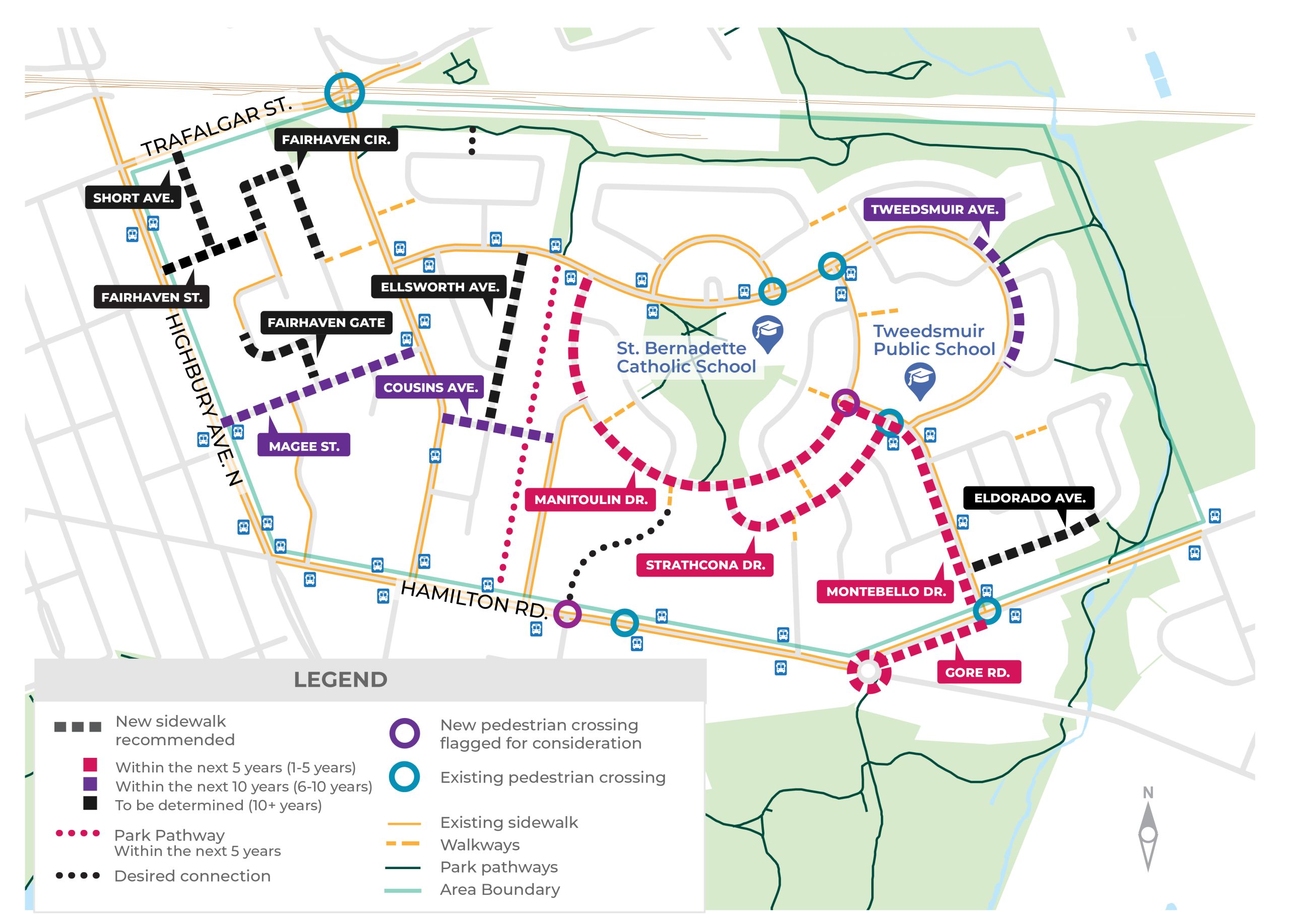

Above: A map graphic showing locations of new sidewalk connections recommended for the Hamilton Road and Fairmont area east of Highbury Avenue, colour-coded to indicate the earliest possible timeframe when roads would be undergo lifecycle renewal. Please note that a previous version of the map mistakenly showed the recommended sidewalk on Fairhaven Street as purple “Within the next 10 years (6-10 years)”, and it has been since corrected to black “To be determined (10+ years)”.


Street

Timing

Location

Program*

The following streets have no sidewalk.
A sidewalk is recommended on one side of the street:

Short Avenue

10+ years

Trafalgar Street to Fairhaven Street

LRRP

Fairhaven Street

10+ years

Highbury Avenue North to Fairhaven Circle

LRRP

Fairhaven Circle

10+ years

Fairhaven Street to Hale Street Walkway

LRRP

Fairhaven Circle

10+ years

Existing Sidewalk to Fairhaven Gate

LRRP

Fairhaven Gate

10+ years

Fairhaven Circle to Magee Street

LRRP

Magee Street

6-10 years

Highbury Avenue North to Hale Street

NSP

Ellsworth Avenue

10+ years

Tweedsmuir Avenue to Cousins Avenue

LRRP

Cousins Avenue

6-10 years

Hale Street to Fairmont Ave

NSP

Manitoulin Drive

1-5 years

Tweedsmuir Avenue to Montebello Drive

NSP

Strathcona Drive

1-5 years

Manitoulin Drive to Montebello Drive

NSP

Eldorado Ave

10+ years

Montebello Drive to Park Pathway Entrance

IRP

The following streets currently have sidewalk on one side.
Sidewalk is recommended on both sides of the street:

Tweedsmuir Avenue

6-10 years

Laurentian Drive North to Arcadia Crescent

NSP

Montebello Drive

1-5 years

Manitoulin Drive to Gore Road

NSP

Park pathway recommended for extension:

Hydro One Corridor

1-5 years

Tweedsmuir Avenue to Hamilton Road

NOS

Arterial Road Improvements:

Hamilton and Gore Road Intersection

1-5 years

Hamilton Road to Montebello Drive

GP

New pedestrian crossing to be reviewed:

Manitoulin Drive

1-5 years

East side of Montebello (existing school crossing)

RSS

Hamilton Road

Monitor

Review if existing PXO, east of Meadowlilly, is in optimal location

RSS

Other walking infrastructure considerations:

Jasper Cres

Monitor

Review potential for access improvements to park pathway

NOS


Table Legend:
*Programs: Sidewalks and pedestrian supportive infrastructure are constructed under various programs:

  • LRRP – Local Road Reconstruction Program
  • NSP – New Sidewalk Program
  • IRP – Infrastructure Renewal Program
  • NOS – New Open Space Program (Park Pathways)
  • GP – Growth Project
  • RSS – Road Safety Strategy

A total of 18 crescents or short streets and 6 courts, listed below, have been recommended for exemption from Mobility Policy 349. Under this approach, existing sidewalks will be reinstated as part of any future infrastructure projects however no new or additional sidewalks will be constructed.

  • Fairhaven Circle (Hale Street Walkway to Fairhaven Gate - #189 to #235)
  • Fairhaven Circle (Addresses #280 to #294)
  • Magee Place
  • Ellsworth Crescent
  • Ellsworth Close
  • Fairway Avenue
  • Jasper Crescent
  • Fairmont Avenue (Cousins Avenue to Manitoulin Drive)
  • Breton Park Crescent
  • Algonquin Crescent
  • Watmar Avenue
  • Hamber Court
  • Niagara Street
  • Fundy Avenue
  • Queenston Crescent
  • Ottawa Court
  • Laurentian Drive N
  • Laurentian Drive S
  • Cornerbrook Avenue
  • Arcadia Crescent
  • Rockwyn Crescent
  • Marbenor Crescent
  • Coldstream Crescent

Eldorado Avenue (Park Access to Coldstream Crescent - #58 to #110)


How to join the public participation meeting (PPM)
The December 2 meeting includes a public participation meeting (PPM) component, meaning you can speak directly to the Community and Protective Services Committee at this meeting, or email comments to the City Clerk’s Office in advance to have them included in the Community and Protective Services Committee agenda.

You can also participate remotely, by preregistering through the Clerk’s Office. For detailed information on the PPM process, visit the City of London website at this link.
The December 2 committee meeting will also be available to livestream on the City of London’s YouTube channel.

What happens after City Council’s decision?
Following Community and Protective Services Committee, Council will meet on December 14 to give final direction on the staff recommendations. When it’s time to construct sidewalks where they have been approved, staff would then return to consult with those residents, with a focus on finding the best fit for the street and helping residents understand the design considerations available to maximize the benefits and mitigate impacts of adding a new sidewalk.

To stay informed about the plan’s development and recommendations, please subscribe here for email updates to follow along with the project. You can also contact ncp@london.ca to ask questions.

Accessibility has been considered in the development of this community engagement plan, however, if you need this material or information in an alternate format, please reach out to the project team and we will work with you to ensure you can participate.


Share Provide your input: Hamilton Road Neighbourhood Connectivity Map on Facebook Share Provide your input: Hamilton Road Neighbourhood Connectivity Map on Twitter Share Provide your input: Hamilton Road Neighbourhood Connectivity Map on Linkedin Email Provide your input: Hamilton Road Neighbourhood Connectivity Map link

Provide your input: Hamilton Road Neighbourhood Connectivity Map

6 months

This map shows the area of your community where City staff will be completing a "Neighbourhood Connectivity Plan" to recommend where sidewalks can provide the most benefit. 

To help us understand community travel patterns and establish key neighbourhood destinations, features and amenities, please use the "+" button on the menu on the left to drag and drop up to three pins for each category onto the map.

Note: If you have already entered your feedback through the online survey, you do not need to duplicate your answers here.  

CLOSED: This map consultation has concluded.
Page last updated: 12 Nov 2024, 08:56 AM